The data that is available on this homepage can be used for purposes that are in the interest of the public, such as environmental preservation, research as well as education objectives. User registration is required to download the data for use.
Copies or reproduction of the information available here for objectives other than those above, such as use for production of secondary works or for public transmission, are forbidden.
Copies or reproduction of the information available here for objectives other than those above, such as use for production of secondary works or for public transmission, are forbidden.
What can we know from the temperature of the sea surface?
Remote Sensing: Using artificial satellites to investigate the earth
Mankind was able to view the round earth with the naked eye for the first time only after traveling into space on a spaceship. When positioned on earth, it is no simple matter to comprehend that the earth is round. There are a lot of things that only become visible at a distance. For instance, meteorological phenomena and sea surface temperatures are an example. With the help of artificial satellites, a wide array of data can be gathered to help us grasp changes occurring on earth as a whole. In this way, investigating, or sensing the earth, from a distance, i.e. somewhere remote, is referred to as”remote sensing.”
Mankind was able to view the round earth with the naked eye for the first time only after traveling into space on a spaceship. When positioned on earth, it is no simple matter to comprehend that the earth is round. There are a lot of things that only become visible at a distance. For instance, meteorological phenomena and sea surface temperatures are an example. With the help of artificial satellites, a wide array of data can be gathered to help us grasp changes occurring on earth as a whole. In this way, investigating, or sensing the earth, from a distance, i.e. somewhere remote, is referred to as”remote sensing.”
What can we learn from remote sensing?
By using electromagnetic waves directed at the surface of the ocean from artificial satellites, we can measure water temperature, phytoplankton concentration, sea-surface altitude, oceanic winds, currents and so on. With this homepage, we will explain about the retrieval of water temperature and phytoplankton concentration information, while introducing ways in which remote sensing data can be used to monitor the marine environment.
By using electromagnetic waves directed at the surface of the ocean from artificial satellites, we can measure water temperature, phytoplankton concentration, sea-surface altitude, oceanic winds, currents and so on. With this homepage, we will explain about the retrieval of water temperature and phytoplankton concentration information, while introducing ways in which remote sensing data can be used to monitor the marine environment.
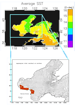
What we can know from the sea-surface temperature distribution.
Due to the infrared rays and microwaves in the electromagnetic waves used, we can measure the temperature of the sea surface.
In this way, data retrieved is used to express sea surface temperature variations by color using SST (Sea Surface Temperature). (see left)
With the help of sea-surface temperature data, we can understand how the marine climates change with the seasons.
In addition, using the temperature distribution data for the ocean, it is possible to comprehend the flow of warm and cold ocean currents. This information is very useful in finding the location of fishing grounds.
This is because fish all have a temperature range that they find most suitable. Applying this knowledge it is possible to predict where they will gather. In this way, fishermen can make an educated guess about where fish will be gathering before they leave port (or while at sea fishing if the vessel is equipped to receive data via satellite) based on this data.
What can we can learn from Chlorophyll a concentrations?
What does measuring Chlorophyll a concentration tell us?
Chlorophyll a (Chl-a) is one type of chlorophyll that plays a basic role in photosynthesis in plants. It is included in phytoplankton in the ocean and its concentration can be regarded as indicating the total about of phytoplankton.
In addition, Chl-a concentrations are used as an indicator or yardstick for measuring marine pollution. This is because Chl-a increases with nutrients that enter the ocean from land, such as nitrogen and phosphorous.
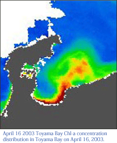
Satellite remote sensing allows the estimation of oceanic Chl-a concentrations by measuring the wavelength of visible radiation originating from the waterÅfs surface. Chl-a concentration can be determined by the color of the water leaving light; greener is higher, because Chl-a present in water absorbs blue light. By measuring the amount of Chl-a a in the water, the distribution of phytoplankton concentrations can be understood.Phytoplankton is food for zooplankton or small fish. When schools of small fish gather to feed on phytoplankton, fish that feed on these phytoplankton eating fish also gather. In this way, fertile fishing grounds are created. It is fair to say that areas with a certain level of phytoplankton concentrations are also areas that are home to a wealth of fish. However, these fishing areas are in a constant change depending on the condition of the marine environment.On one hand, when phytoplankton appear in mass, or create a bloom, they can cause a red tide or a blue tide.The major cause of these algae blooms is thought to be caused by wastewater from homes, factories and elsewhere, the nitrogen and phosphorous of which runs into rivers that feed into the ocean creating an environment conducive to plankton reproduction (known as eutrophication).Monitoring of daily chlorophyll a concentration distributions is useful to help better understand the marine environment and the mechanism that drives red and blue tides
More about remote sensing
Regularly gathering data from the same areas with artificial satellites
Artificial satellites can be used to gather a broad range of data in nearly real-time. In addition, Geostationary satellites can be used to constantly monitor the same area of the planet, as is the case with meteorological satellites used for weather forecasts, such as the Himawari satellite of Japan with which many people are familiar.
Moreover, using polar orbital satellites that pass above the North Pole and South Pole, it is possible to monitor the entire planet.
 Gathering data with light humans can’t even see
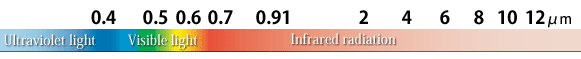
Artificial satellites are operated via remote control — essentially a kind of functioning robot. This is especially true for artificial satellites that are used for remote sensing, as these are robots built on cameras. As such, depending on the type of camera with which these satellites are equipped, they can of course pick up (visible) light as well as light or radiation in a range of the spectrum invisible to the human eye, such as infrared and ultraviolet light. These images can then be viewed in the form of a picture. For example, by combining infrared data of different wavelength, an array of information, including earth surface temperatures, chlorophyll a distribution and vegetation indicators, can be derived.
In addition, with certain sensors, radio waves can be directed at the earth and used as radar, with the data that is bounced back and received by the satellite being used to perceive the earth’s surface. This is sometimes possible even in the event of cloud cover.For individuals interested in more detailed information, we recommend a visit to the following sites.
·JAXA|Kid’s page
·JAXA/EORC On the frontline of using satellite images – what is earth observation?
· RESTEC (As a reference about remote sensing)
Artificial satellites can be used to gather a broad range of data in nearly real-time. In addition, Geostationary satellites can be used to constantly monitor the same area of the planet, as is the case with meteorological satellites used for weather forecasts, such as the Himawari satellite of Japan with which many people are familiar.
Moreover, using polar orbital satellites that pass above the North Pole and South Pole, it is possible to monitor the entire planet.
Gathering data with light humans can’t even seeArtificial satellites are operated via remote control — essentially a kind of functioning robot. This is especially true for artificial satellites that are used for remote sensing, as these are robots built on cameras. As such, depending on the type of camera with which these satellites are equipped, they can of course pick up (visible) light as well as light or radiation in a range of the spectrum invisible to the human eye, such as infrared and ultraviolet light. These images can then be viewed in the form of a picture. For example, by combining infrared data of different wavelength, an array of information, including earth surface temperatures, chlorophyll a distribution and vegetation indicators, can be derived.
In addition, with certain sensors, radio waves can be directed at the earth and used as radar, with the data that is bounced back and received by the satellite being used to perceive the earth’s surface. This is sometimes possible even in the event of cloud cover.For individuals interested in more detailed information, we recommend a visit to the following sites.
·JAXA|Kid’s page
·JAXA/EORC On the frontline of using satellite images – what is earth observation?
· RESTEC (As a reference about remote sensing)