Why we use remotely sensed data by satellites for marine environmental monitoring
Remote sensing technique enables us to obtain data of sea surface temperature (SST) and chlorophyll-a (Chl-a) concentration which indicates the volume of phytoplankton in the ocean.
Phytoplankton is the basis for primary production. When the ocean becomes eutrophic by excess nutrition loads, phytoplankton grows extensively, which often leads occurrence of red tides. By using remote sensing data on Chl-a concentration, we can keep our eyes on the state of the ocean.
Phytoplankton is the basis for primary production. When the ocean becomes eutrophic by excess nutrition loads, phytoplankton grows extensively, which often leads occurrence of red tides. By using remote sensing data on Chl-a concentration, we can keep our eyes on the state of the ocean.
Advantages of using remote sensing technique
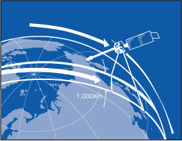
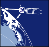
The biggest advantage of using remote sensing technique is its coverage in monitoring the marine environment. In other words, artificial satellites can cover a wide range of geographical areas in one observation.
While orbiting the earth at a fast speed (7 km/sec.), satellites can capture an area as long as 2,000 km in one picture.
While orbiting the earth at a fast speed (7 km/sec.), satellites can capture an area as long as 2,000 km in one picture.
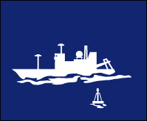
They also monitor the same areas automatically, and replication in observation is another advantage. In case of ship-board observation, we cannot observe the ocean on a daily basis, and we cannot cover an area of hundreds of kilometers in one time, either. Remote sensing, however, can manage these challenges, so it is useful to understand seasonal and/or annual changes of the state of the marine environment.
Disadvantages of using remote sensing technique
Since artificial satellites observe the earth from the sky, there are some disadvantages:
- Accuracy of the measurement may be lower than ship-board (in-site)
- In most cases, only water temperature at sea surface is measured but not under the surface layer
- Clouds prevents satellite from observing with visible lights and infrared wavelengths.
Also, estimation of Chl-a concentration in coastal areas in particular, is sometimes inaccurate because of turbid water from the land
| Observation | Remote Sensing Observation Satellite data | In situ Observation Sea-truth data |
| Advantage |
|
|
| Disadvantage |
|
|