Since 2001, the Environment Ministry and the Northwest Pacific Region Environmental Cooperation Center have been promoting the Marine Environmental Watch Project as a means of establishing a system to distribute marine environment data, gathered by satellites and analyzed, to NOWPAP affiliated countries and other nations.
Northwest Pacific Action Plan (NOWPAP) has been implemented by the People’s Republic of China, Japan, the Republic of Korea, and the Russian Federation in September 1994 as a part of the Regional Seas Programme of the United Nations Environment Programme since 1994.
The overall goal of the NOWPAP is “the wise use, development and management of the coastal and marine environment so as to obtain the utmost long-term benefits for the human populations of the region, while protecting human health, ecological integrity and the region’s sustainability for future generations”.
To implement the NOWPAP, regional activity center was established in each NOWPAP member country. Special Monitoring and Coastal Environmental Assessment Centre (CEARAC) was established in Japan, hosted by Northwest Pacific Region Environmental Cooperation Center (NPEC), to develop a special monitoring program of marine environment by utilizing remote sensing techniques in 2002.
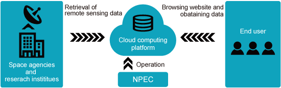
Ministry of the Environment, Japan initiated “Marine Environmental Watch Project” to fulfill this international mission assigned to Japan. This project is implemented by NPEC and it enables grasping the current status of the marine environment in the NOWPAP sea area covering 121o E to 143o E longitude and from approximately 33o N to 52o N latitude in real time by using remote sensing techniques. This project provides data and information to discuss marine environment monitoring methods with the countries concerned. The Marine Environmental Watch Project has registered as one of databases of NEAR-GOOS (North-East Asian Regional GOOS), which is one of the regional GOOS (Global Ocean Observation System) sponsored by Intergovernmental Oceanographic Commission of UNESCO (IOC) since 2007. Since 2019, data retrieval and processing system was moved and reconstructed on a cloud computing platform to efficiently implement the project.
1. Construction of remote sensing data acquisition and processing system
Building a system that automatically acquires remote sensing data released by space agencies and research institutes on a cloud computing environment, then processes and visualize the data for the NOWPAP sea area.
2. Construction of a remote sensing data provision system on a website
Building a database to store remote sensing data acquired by satellites for a long period of time, and to enable retrieval and utilization of the data for various research purposes.
3. Provision of web tools for remote sensing data analysis
Providing web tools to evaluate accuracy of remote sensing data and mapping coastal habitats including seagrass beds.
The project is jointly implemented by the following two organizations
| Ministry of the Environment, Japan | Responsible for developing a system for remote sensing data retrieval, processing, evaluation verification, and analysis systems will be developed in a cloud computing platform. |
| Northwest Pacific Environmental Cooperation Center |
Responsible for operating and managing the system and website built on a cloud computing platform to provide processed data and associated information on a near real time basis. |
Click here for more details